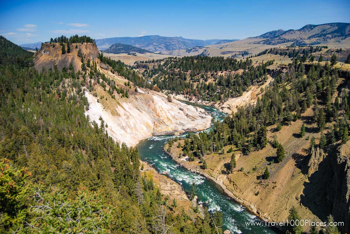
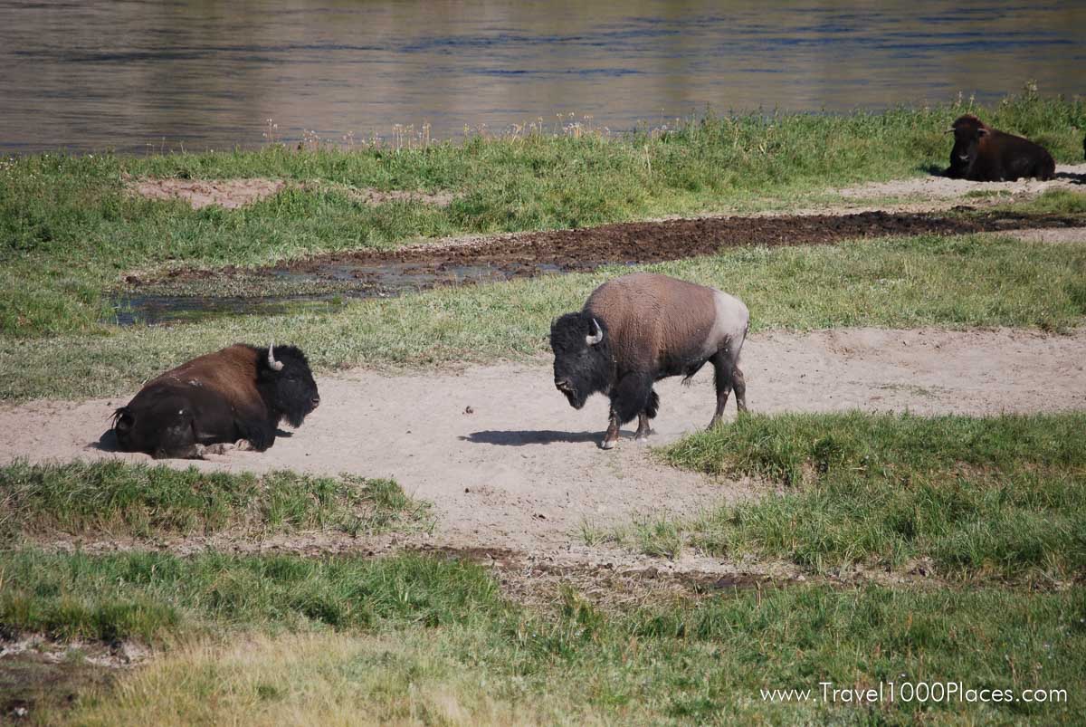
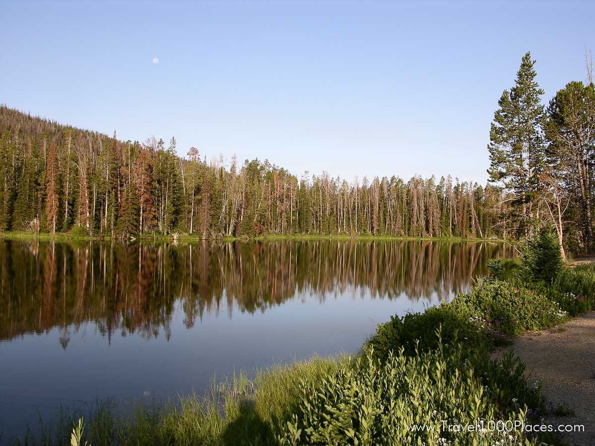
Established in 1872, Yellowstone National Park is America’s first national park. Located in Wyoming, Montana, and Idaho, it is home to a large variety of wildlife including grizzly bears, wolves, bison, and elk. Preserved within Yellowstone National Park are Old Faithful and a collection of the world’s most extraordinary geysers and hot springs, and the Grand Canyon of the Yellowstone.
Wolves
There were no wolves in Yellowstone in 1994. The wolves that were reintroduced in 1995 and 1996 thrived and there are now over 300 of their descendents living in the Greater Yellowstone Area.
Geysers
Yellowstone contains approximately one-half of the world’s hydrothermal features. There are over 10,000 hydrothermal features, including over 300 geysers, in the park.
Roosevelt Arch
The first major entrance for Yellowstone was at the north boundary. Before 1903, trains would bring visitors to Cinnabar, Montana, which was a few miles northwest of Gardiner, Montana, and people would climb onto horse-drawn coaches there to enter the park. In 1903, the railway finally came to Gardiner, and people entered through an enormous stone archway.
Robert Reamer, a famous architect in Yellowstone, designed the immense stone arch for coaches to travel through on their way into the park. At the time of the arch’s construction, President Theodore Roosevelt was visiting the park. He consequently placed the cornerstone for the arch, which then took his name.
The top of the Roosevelt Arch is inscribed with “For the benefit and enjoyment of the people,” which is from the Organic Act of 1916.
Map / Location
Admission 2020
Good for entry into Yellowstone National Park for seven days from the date of purchase.
- Private, non-commercial vehicle: $35.oo
- Motorcycle or snowmobile: $30.oo
- Individual (by foot, bicycle, ski, etc.): $20.oo/person
Further information on the official Website: https://www.nps.gov/yell/
Tip to save money: America the Beautiful is the name of the Annual National Park Pass valid for ALL National Parks in the USA. Check it out here: America the Beautiful Annual National Park Pass
Camping
Yellowstone offers 12 campgrounds with over 2,000 sites. Five of these campgrounds can be reserved, the rest are first-come, first-served.
Please find all details on the official Park Website: https://www.nps.gov/yell/planyourvisit/campgrounds.htm
Lodging / Hotels
Yellowstone National Park Lodges operates nine lodges (hotel- and cabin-style) in the park with more than 2,000 rooms. All are open from late spring through fall, but only two are open in the winter: Old Faithful Snow Lodge and Mammoth Hot Springs Hotel.
Please find all details on the official Park Website: https://www.nps.gov/yell/planyourvisit/lodging.htm
Weather and Climate
Summer: Daytime temperatures are often in the 70s (25C) and occasionally in the 80s (30C) in lower elevations. Nights are usually cool and temperatures may drop below freezing at higher elevations. Thunderstorms are common in the afternoons.
Winter: Temperatures often range from zero to 20F(-20 to -5C) throughout the day. Sub-zero temperatures over-night are common. The record low temperature is -66F (-54C). Snowfall is highly variable. While the average is 150 inches per year, it is not uncommon for higher elevations to get twice that amount.
Spring & Fall: Daytime temperatures range from the 30s to the 60s (0 to 20C) with overnight lows in the teens to single digits (-5 to -20C). Snow is common in the Spring and Fall with regular accumulations of 12″ in a 24 hour period. At any time of year, be prepared for sudden changes. Unpredictability, more than anything else, characterizes Yellowstone’s weather. Always be equipped with a wide range of clothing options. Be sure to bring a warm jacket and rain gear even in the summer.
Interesting facts
Some facts about Yellowstone NP
- World’s First National Park
- A designated World Heritage Site
- A designated Biosphere Reserve Site
- 3,472 square miles or 8,987 square km
- 2,219,789 acres or 898,317 ectares
- 63 air miles north to south (102 km)
- 54 air miles east to west 87 km)
- 96 % in Wyoming
- 3 % in Montana
- 1 % in Idaho
- Highest Point: 11,358 ft / 3,462 m (Eagle Peak)
- Lowest Point: 5,282 ft / 1,610 m (Reese Creek)
- Larger than Rhode Island and Delaware combined
- Approximately 5% of park is covered by water; 15% is grassland; and 80% is forested
- Precipitation ranges from 10 inches (26 cm) at the north boundary to 80 inches (205 cm) in the southwest corner
- Temperatures (average) range from 9 F / -13 C in January to 80 F / 27 C in July at Mammoth Hot Springs
- Record High Temp: 98 F / 37 C (Lamar 1936)
- Record Low Temp: -66 F / -54 C (Madison 1933)
WILDLIFE
- 7 species of native ungulates
- 2 species of bears
- Approximately 50 species of other mammals
- 311 recorded species of birds (148 nesting species)
- 18 species of fish (6 non-native)
- 6 species of reptiles
- 4 species of amphibians
- 5 species protected as “threatened or endangered”
Threatened: bald eagle, grizzly bear, lynx
Endangered: whooping crane, gray wolf
FLORA
- 8 species of conifers
- Approximately 80% of forest is comprised of lodgepole pine
- More than 1,700 species of native vascular plants
- More than 170 species of exotic (non-native) plants
- 186 species of lichens
GEOLOGY
- An Active Volcano
- Approximately 2,000 earthquakes annually
- Approximately 10,000 thermal features
- More than 300 geysers
- One of the world’s largest calderas, measuring 45 by 30 miles (72 by 48 km)
- One of the world’s largest petrified forests
- Approximately 290 waterfalls, 15 ft. or higher, flowing year-round
- Tallest waterfall: Lower Falls of the Yellowstone River at 308 ft. (94 m)
YELLOWSTONE LAKE
- 136 sq. miles (35,400 hectares) of surface area
- 110 miles (177 km) of shoreline
- 20 miles (32 km) north to south
- 14 miles (23 km) east to west
- Average depth: 140 feet (43 m)
- Maximum depth: about 400 feet (122 m)
ROADS AND TRAILS
- 5 park entrances
- 466 mi / 750 km of roads (310 mi/499 km paved miles)
- 950 mi / 1,529 km of backcountry trails
- 97 trailheads
- 287 backcountry campsites
VISITATION
- 2000 – 2,838,233 visitors
- Record year: 1992 – 3,144,405 visitors
- Winter visitors: Approximately 140,000
FACILITIES
- 9 visitor centers and museums
- 9 hotels/lodges (2,238 hotel rooms/cabins)
- 7 NPS-operated campgrounds (454 sites)
- 5 concession-operated campgrounds (1,747 sites)
- 2,000+ buildings (NPS and concessions)
- 49 picnic areas
- 1 marina
Welcome to the Old Faithful area, also known as the Upper Geyser Basin.
The Upper Geyser Basin
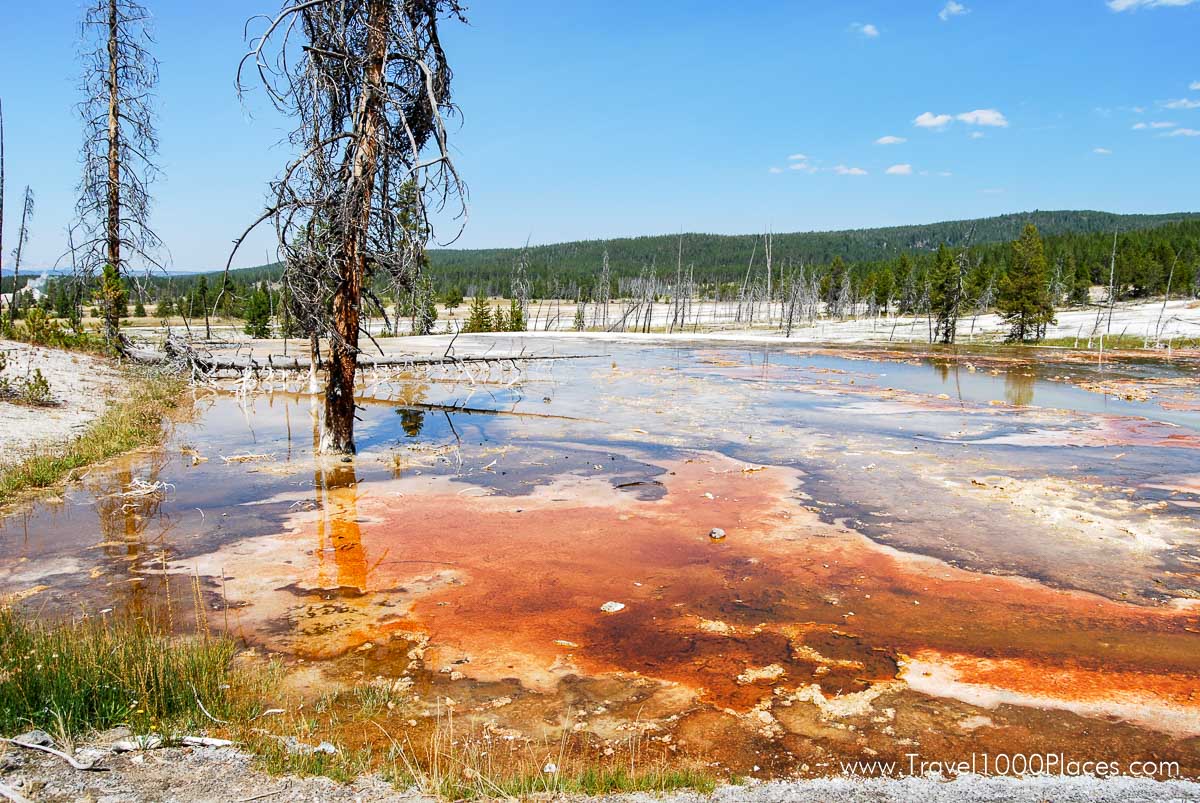
Yellowstone, as a whole, possesses close to 60 percent of the world’s geysers. The Upper Geyser Basin is home to the largest numbers of this fragile feature found in the park. Within one square mile there are at least 150 of these hydrothermal wonders. Of this remarkable number, only five major geysers are predicted regularly by the naturalist staff. They are Castle, Grand, Daisy, Riverside, and Old Faithful.
There are many frequent, smaller geysers to be seen and marveled at in this basin as well as numerous hot springs and one recently developed mudpot (if it lasts).
Biscuit Basin is one of three basins that make up the Upper Geyser Basin.
The name Biscuit Basin was adopted in the late 1880s because of the unusual biscuit-shaped geyserite formations that used to surround Sapphire Pool. Following the 1959 Hebgen Lake earthquake, Sapphire erupted—and the “biscuits” were blown away.
Castle Geyser has the largest cone and may be the oldest of all geysers in the basin. Its eruption pattern has changed considerably throughout its recorded history. Castle is currently erupting about every 10 – 12 hours. A water eruption frequently reaches 90 feet (27m) and lasts about 20 minutes. The water phase is followed by a noisy steam phase lasting 30 – 40 minutes.
Lower Geyser Basin
This large area of hydrothermal activity can be viewed by foot along the boardwalk trail at Fountain Paint Pots and by car along the three mile Firehole Lake Drive. The latter is a one-way drive where you will find the sixth geyser predicted by the Old Faithful staff: Great Fountain. Its splashy eruptions send jets of diamond droplets bursting 100-200 feet in the air, while waves of water cascade down the raised terraces. Patience is a virtue with this twice-a-day geyser, as the predictions allow a 2 hour +/- window of opportunity.
Fountain Flats Drive departs the Grand Loop Road just south of the Nez Perce picnic area and follows along the Firehole River to a trailhead 1.5 miles distant.
From there, the Fountain Freight Road hiking/biking trail continues along the old roadbed giving hikers access to the Sentinel Meadows Trail and the Fairy Falls Trail. Also along this path is the only handicapped-accessible backcountry site in the Old Faithful district at Goose Lake.
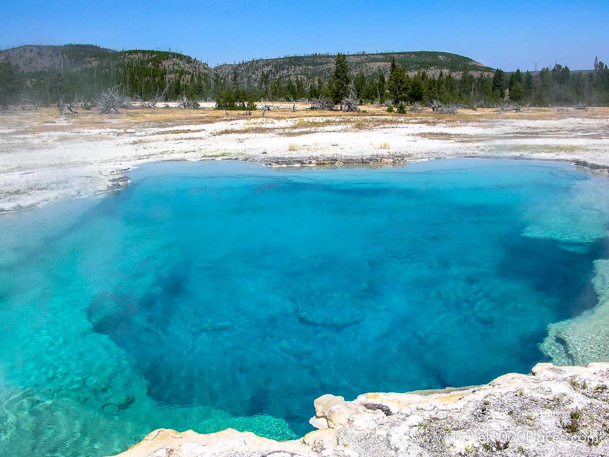
Midway Geyser Basin
This geyser basin, though small in size compared to its companions along the Firehole River, holds large wonders for the visitor. Excelsior Geyser reveals a gaping crater 200 x 300 feet with a constant discharge of more than 4,000 gallons of water per minute into the Firehole River. Also in this surprising basin is Yellowstone’s largest hot springs, Grand Prismatic Spring. This feature is 370 feet in diameter and more than 121 feet in depth.
Lone Star Geyser Basin
This backcountry geyser basin is easily reached by a 5-mile roundtrip hike from the trailhead south of Old Faithful. Lone Star Geyser erupts about every three hours. There is a logbook, located in a cache near the geyser, for observations of geyser times and types of eruptions.
Shoshone Geyser Basin
Shoshone Geyser Basin is reached by a 17-mile roundtrip hike that crosses the Continental Divide at Grant’s Pass. This basin has no boardwalks, and extreme caution should be exercised when travelling through it. Trails in the basin must be used. Remote thermal areas, such as this, should be approached with respect, knowledge, and care. Be sure to emphasize personal safety and resource protection when entering a backcountry basin.
Firehole River
The river derives its name from the steam (which they thought was smoke from fires) witnessed by early trappers to the area. Their term for a mountain valley was “hole,” and the designation was born. The Firehole River boasts a world-famous reputation for challenging fly-fishing. Brown, rainbow, and brook trout give the angler a wary target in this stream.
Continental Divide at Craig Pass
Craig Pass/Isa Lake
Both names are used to describe the same location seven miles south of Old Faithful on the Grand Loop Road. At 8,262 feet along the Continental Divide, Isa Lake is a uniquely confusing feature. During spring runoff, it drains into both the Atlantic and Pacific Oceans at the same time! (And backwards, too!) The west side of the lake flows into the Firehole drainage and, eventually, the Atlantic throughout the year. The east side, during spring, flows toward the Snake River drainage and the Pacific.
Waterfalls
Kepler Cascades is the most easily reached waterfall in the district. A marked pullout just south of Old Faithful and a short walk from the car offers the visitor easy access to view this 125-foot cascade.
Mystic Falls and Fairy Falls: (see Day Hiking Trails section for information on these features).
Mammoth Area – Yellowstone National Park: Geysers & Hot Springs
Mammoth Hot Springs
Mammoth Hot Springs are the main attraction of the Mammoth District. These features are quite different from thermal areas elsewhere in the park. Travertine formations grow much more rapidly than sinter formations due to the softer nature of limestone. As hot water rises through limestone, large quantities of rock are dissolved by the hot water, and a white chalky mineral is deposited on the surface.
Although visitors are sometimes confused by the rapidly shifting activity of the hot springs and disappointed when a favorite spring appears to have “died,” it is important to realize that the location of springs and the rate of flow changes daily, that “on-again-off-again” is the rule, and that the overall volume of water discharged by all of the springs fluctuates little.
Mammoth Hot Springs are the main attraction of the Mammoth District. These features are quite different from thermal areas elsewhere in the park. Travertine formations grow much more rapidly than sinter formations due to the softer nature of limestone. As hot water rises through limestone, large quantities of rock are dissolved by the hot water, and a white chalky mineral is deposited on the surface.
The Gardner River and Gardner River Canyon
The North Entrance Road from Gardiner, Montana, to Mammoth Hot Springs, Wyoming, runs along the Gardner River. The road winds into the park, up the canyon, past crumbling walls of sandstone and ancient mudflows. The vegetation is much thicker in the canyon than on the open prairie down below, the common trees being Rocky Mountain juniper, cottonwood, and Douglas-fir. Low-growing willows also crowd the river’s edge in the flatter, flood-prone sections of the canyon.
Watch for wildlife in season: eagles, osprey, dippers, and kingfishers along the river and bighorn sheep in the steeper parts of the canyon.
45th Parallel Bridge and Boiling River
A sign near where the road crosses the Gardner River marks the 45th parallel of latitude. The 45th parallel is an imaginary line that circles the globe halfway between the equator and the North Pole. This same line passes through Minneapolis-St. Paul, Ottawa, Bordeaux, Venice, Belgrade, and the northern tip of the Japanese islands. It is, here in Yellowstone, roughly aligned with the Montana-Wyoming border.
A parking area on the east side of the road is used by bathers in the “Boiling River.” Bathers must walk upstream about a half mile from the parking area to the place where the footpath reaches the river. This spot is also marked by large clouds of steam, especially in cold weather. Here, a large hot spring, known as Boiling River, enters the Gardner River. The hot and the cold water mix in pools along the river’s edge. Bathers are allowed in the river during daylight hours only. Bathing suits are required, and no alcoholic beverages are allowed. Boiling River is closed in the springtime due to hazardous high water and often does not reopen until mid-summer.
The Yellowstone Park Foundation funded the Boiling River Trail Project. They are a non-profit organization whose mission is to fund projects and programs that protect, preserve and enhance Yellowstone National Park.
Mt. Everts
Mt. Everts was named for explorer Truman Everts of the 1870 Washburn Expedition who became separated from his camping buddies, lost his glasses, lost his horse, and spent the next 37 days starving and freezing and hallucinating as he made his way through the untracked and inhospitable wilderness. Upon rescue, he was, according to his rescuers, within but a few hours of death. Everts never made it quite as far as Mt. Everts. He was found near the “Cut” on the Blacktail Plateau Drive and was mistaken for a black bear and nearly shot. His story, which he later published in Scribner’s Monthly Magazine, remains one of Yellowstone’s best known, lost-in-the-wilderness stories. It has also been published in book form, edited by Yellowstone’s archivist Lee Whittlesey under the name Lost in the Yellowstone.
Mt. Everts is made up of distinctly layered sandstones and shales–sedimentary rocks deposited when this area was covered by a shallow inland sea, 70 to 140 million years ago.
Bunsen Peak
Bunsen Peak and the “Bunsen burner” were both named for the German physicist, Robert Wilhelm Bunsen. Although most people are familiar with the “Bunsen burner,” few people know why his students gave the burner that name. He was involved in pioneering research about geysers, and a “Bunsen burner” has a resemblance to a geyser. His theory on geysers was published in the 1800s, and it is still believed to be accurate.
Bunsen Peak is 8,564 feet high (2,612 meters) and may be climbed via a trail that starts at the Golden Gate. Another trail, the old Bunsen Peak road, skirts around the flank of the peak from the YCC camp to the Golden Gate. This old road may be used by hikers, mountain-bikers, and skiers in winter.
The peak is also interesting because it burned in the 1880s and then again in 1988. A series of old photos show the creep of trees up Bunsen following the 1880 fires, and the new patterns of open space created by the fires of 1988.
Further information
Official Website: https://www.nps.gov/yell/
