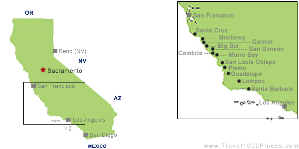
Highway No. 1 – it’s one of the well-known coastal roads in the nation. The 470 mile (756 km) stretch between Los Angeles and San Francisco is the most driven part of this even longer road.
The road in a nutshell
Highway 1, that is the stretch that follows directly the coast line, elsewhere it’s named Highway 101.
The road begins south of Leggett in North California, reaches Mendocino and then San Francisco. Many travelers start here their way south and visit the Monterey peninsula, drive via San Louis Obispo to Lompoc, Santa Barbara and eventually Los Angeles. The highway final stretch leads close to San Clemente, where Highway 101 meets Highway 5.
Name
Even if a road atlas refers to to famous highway as “California 1” it’s for travelers just and in a classic manner “Highway No 1” or “The Pacific Coast Highway“. Latter name hits the nail on its head: it is an impressive scenic road along the rugged coastline of the Pacific Ocean – it’s even more: it offers an emotional drive along one of the best coasts in the world.
Let’s start! Get directions
What is the suggested and best direction? North to South or vice versa? However you may decide, it’s beautiful anyway, but many say that they prefer South to North, because the journey end in the city with the most ambience: San Francisco.
How long will the drive on Highway No. 1 take?
No doubt about it… you might do it in one day! But: this is not a road for travelers in a hurry. This scenery along the coast must be enjoyed and needs time. And considering that the summer travel season brings zillions of tourists to California this road can get crowded. Big RV’s making their way on the winding road, slow cars with people looking around and bikers enjoying views and the ocean breeze make it anyway difficult to step on the gas.
An optimal time frame is between 2 and 5 days – they longer you can afford, the better, because you have the chance to stop more often at magnificent beach stretches and relaxing towns.
Los Angeles, Malibu, Santa Barbara, Lompoc
Once leaving metro L.A. one feels that the journey may begin. Now you’re on your way to Malibu.
Malibu
Malibu is a nice celebrity town with about 12.000 residents, which is really worth to get discovered. Check out the 27-miles of beautiful beaches, the steep coast stretches and the pier. After a coffee continue your trip to Santa Barbara, which tops Malibu regarding exclusivity and outnumbers it by celebs. After being driving for approx. 2 hours you’ll arrive at Malibu.
Santa Barbara
Santa Barbara has its reputation for being expensive, exclusive, clean and of course a little touristy. You’ll need deep pockets if you’d like to go shopping in the nice shops.
But there’s history to discover as well: the “Mission Santa Barbara”, which has the nickname “Queen of the Missions”, was built in 1786 as the 10th of 21 missions in California.
Hungry? At Stearns Wharf you get the chance to find seafood or other tasty stuff. The pier is full of restaurants and shops, so you can walk off the meal afterwards. Don’t miss the opportunity to take a photo at the Dolphin Fountains, sculptured by local artist Bud Bottoms.
An attraction of a different kind is a special tree: it is said to be the ‘biggest fig tree‘ on earth – located at Chapala and Montecito streets. At least this tree is registered as one of the biggest trees in California. The “Moreton Bay Fig Tree” now spans more than 165 ft (50 m), its height is about 78 ft (24 m) and was planted in 1874 by a sailor, who returned from a trip to Australia. It’s said that it was a gift for his loved one and he planted the seedling in her garden. Later, a new homeowner brought the tree to its current location.
When you feel that you are ready to continue your trip you’re actually heading towards another town with a botanical highlight:
Lompoc
Lompoc (~44.000 people) is the name of the little town, which has adopted the meaningful slogan: “The mural city in the valley of flowers” or also: “City of Arts & Flowers”.
Arts and flowers dominate the little town. More than 60 murals are now finished. The history dates back more than 10.000 years before the first European arrived here. The Chumash Indians lived here, and their history is captured in the Lompoc Museum in downtown. From the language of the Chumash Indians derives the name Lompoc, which means “little lake or lagoon”. By the way, the name is pronounced “Lom-Poke” – never Lom-pock.
Flower valley gives already a hint what the visitor can expect: flower fields wherever you look – most of all flower seeds for the entire world are coming from Lompoc.
When visiting in June, don’t miss the Annual Flower Festival mid / late June. The first European settlers in the region built in 1787 the Spanish Mission “La Purisma Conception Maria Santisima“, which has undergone restoration can be visited nearby. The 10.000-acre (40.000qm) park invites to relax.
Further along the coast on our way north we find the little town of Guadalupe. Well known in this area and popular as movie setting are the Guadalupe-Nipomo Dunes which are rising more than 500 ft into the sky (150 m) – thus they belong to the highest in the nation. Web: Guadalupe-Nipomo Dunes National Wildlife Refuge – Guadalupe-Nipomo Dunes – U.S. Fish and Wildlife Service (fws.gov)
Pismo – San Louis Obispo – Morro Bay
Pismo is probably the next stop, one should plan, may be on your second day. Don’t be here too early, because you must expect morning fog or mist as it’s normal for the entire coast region. About 20 mi (32 km) of beaches are waiting, which translates into relaxing, canoeing or horse riding. After some physical activity the time might be ripe to taste the so famous Clam Chowder Soup or any other recipe with clams, for which the town has its reputation. Once there were extraordinary big – today it’s no more mentionable.
Then drive further north and come to San Louis Obispo. This also means, that it’s time for another Spanish mission. It is “Mission San Louis Obispo de Tolosa”, the 5th one built along the coast in the year 1772.
The Madonna Inn is a theme hotel and landmark on this stretch of the coast since the 1950’s. More than 100 rooms, each in a special color design or decorated with a special theme. And: Don’t miss to check out the bathrooms – they probably lure alone hundreds of ‘bathroom tourists’ to the Madonna Inn. It’s about the Men’s room – but expect to meet here curious women, too.
When leaving San Louis Obispo, you may decide to have enough time to make the short trip to the Montana de Oro State Park – it’s a fantastic place to shoot some great photos. You overlook the Pacific Ocean and probably enjoy the drive through Eucalyptus forests. After hitting the beach and relaxing for a while you can continue with your trip.
“Gibraltar of the Pacific” is our next stop named: Morro Bay. Here everything is about a 574 ft (175 m) high rock – once a volcano – in midst of the harbor. The best time to come here is in the late afternoon to get the chance to seize the moment when the sun dips into the ocean.
Today, on the rock live thousands of bird, among them some endangered species. Once a Spanish harbor, Morro Bay is nowadays a modern, touristy town. In case you’re interested in aquariums, then visit the rehabilitation center for mammals, located in the Morro Bay Aquarium. Children are allowed to feed the seals here.
Cambria – Piedras Blancas – Big Sur – Carmel
A little further north we will reach Cambria, a small town in Victorian look. Small shops and restaurants along Main Street invite to stay a little longer. Or stroll along Moonstone Beach Drive, just off Highway 1, and watch the ocean, may be a sunset…
Next stop on out journey is Hearst Castle, situated only a short drive before reaching San Simeon. Right off Highway 1 is the parking lot from where the shuttle bus to the castle departs. Publisher William Randolph Hearst was the builder and owner of this huge mansion, which he started to build in 1919 and never finished. He called his house not a castle but “the Ranch”. The main building had 115 rooms, 50 more are to find in 3 guest houses. “The Ranch” is situated on a 1.600 ft (500 m) high hill named ‘La Cuesta Encantada’ – the enchanted mountain. The property with an area of 126 acres (500.000 qm) overlooks the city of San Simeon and of course the Pacific Ocean. In 1947 Hearst stopped developing “the Ranch” and died in 1951. There a different guided tours offered, each showing other parts of the property.
Read more about Hearst Castle: Hearst Castle, San Simeon, California, USA
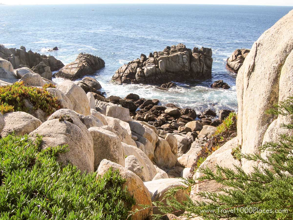
Big Sur — Many say that this is the most impressive stretch of Highway No.1: on your west side you have the Pacific with a steep coastline and on the east side the 5.000 ft (1,500 m) Santa Lucia Mountains.
Big Sur Coast, that’s a 90 miles experience, which ends south of Carmel in the beautiful Monterey Bay.
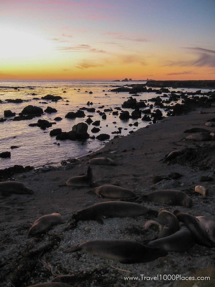
When leaving San Simeon, make sure to look for a lighthouse and a parking lot on the west side of the street (an approx. 6 mi drive from San Simeon). This fantastic view announces what you can expect from the Big Sur Coast. A short trail leads you to the beach, where sometimes seal colonies can be observed.
After an about 60 miles drive along the coast you reach the town of Big Sur. West of it there is another “Don’t miss” spot: Pfeiffer Beach, a really small, but very romantic beach, which is popular among visitors to wait for the sunset. The road to the beach is not easy to see from Highway 1. Sycamore Canyon Rd. is about 2 miles long, beginning somewhere between the post office of Big Sur and the Pfeiffer Big Sur State Park. Big RV’s will have some problems on this road. At the end of the road there’s the parking lot. It’s not allowed to stay overnight.
Carmel is reached after another ca. 28 miles drive and is our next halt. The city is renowned for its numerous residences of celebrities. One of the most visited attractions is one of the most famous Spanish missions, “Basilica San Carlos Borromeo del Rio Carmelo”, which was built in 1771 and where Father Junipero Serra, who started the missions, found his last rest.
More to read about Big Sur Coast, San Simeon, Carmel and Pfeiffer Beach: Visit the Big Sur Coast, California, USA
17 Miles Drive to Monterey to Castroville – Santa Cruz – San Francisco
In Carmel begins the well-known “17 Miles Drive“, a wonderful scenic drive along the peninsula coast and ending in Monterey. It’s a private road and a small fee of ca. $10 has to be paid. But: it pays off and you will enjoy fantastic views, seeing small communities with luxurious houses and a lot of golf courses. It’s a good idea to make a stop at Pebble Beach with its upscale shops.
Monterey offers besides of its natural beauty great opportunities to shop, dine, relax and tour the attractions like Cannery Row, the well renowned Monterey Aquarium or for example Fisherman’s Wharf. Cannery Row, as the name suggests, was once the place where fish (mostly sardines) were canned. Later, John Steinbeck choose it as the location for his novel “Cannery Row”.
Fisherman’s Wharf, too, has the old times left behind – today you find here galleries and shops instead of commercial fishery.
Meanwhile you’re not more than 100 miles away from San Francisco und the route leads you away from the coast into the heart of the Monterey area farmland and to the small town of Castroville, which incorporated the slogan “The Artichoke Capital of the World“: nothing more to say, just drive along Merrit Street, which is actually Main Street, and you find farmers selling artichokes and products. Mid of May takes the “Artichoke Festival” place.
Just 4 miles further on Highway 1 you will reach once again the coast at Moss Landing, once a small fishing village. If you’re hungry, this is a good place to have snack – it’s all about seafood and fish in this town. Have a try.
Coming closer to the S.F. Bay Area, the city of Santa Cruz is the last city at the coastline before you enter the crowded Bay Area. The city reminds of New York’s Coney Island with its amusement park. Some of the rides are pretty historical, i.e. the Roller Coaster of 1924 or the Loof Carousel (1911).
Sport fans may instead decide for the Santa Cruz Surf Museum housed in the Mark Abbott Memorial Lighthouse (West Cliff Drive). Web: Surfing Museum | City of Santa Cruz
From Santa Cruz it’s only a stone’s throw to San Francisco. If you want to enjoy swimming a last time before entering the metro area of the bay, do it between Santa Cruz and Half Moon Bay, where several nice spots can be found.
