The Park in a nutshell
Some rocks at the canyon bottom are estimated to be close to 2000 million years old. The Canyon itself has formed only in the past five or six million years.
The Grand Canyon is more than a great chasm carved over millennia through the rocks of the Colorado Plateau. It is more than an awe-inspiring view. It is more than a pleasuring ground for those that explore the roads, hike the trails, or float the currents of the turbulent Colorado River. The Canyon became a National Park in 1919.
Grand Canyon National Park (South Rim) is located 60 miles north of Williams, Arizona (via route 64 from Interstate 40) and 80 miles northwest of Flagstaff (via route 180). Grand Canyon lies entirely within the state of Arizona.
Between 4 and 5 million visitors come to the Grand Canyon every year – most of them visit the South Rim, which is the more developed one with regard to visitors. A free shuttle bus allows you to travel traffic jam free along the south rim.
The large and modern visitor center in Grand Canyon Village, South Rim, should be your first stop. Rangers are present an answer your questions. A model of the Grand Canyon gives an insight of the size and shape of the canyon. You also find a free National Park Newspaper, The Guide, here in the visitor center with many information around the park, ranger programs, and events.
Even if you don’t plan on walking much, the Rim Trail starting at the visitors center is a short walk and offers spectacular views. If you like hiking, the park offers fantastic routes down to the Colorado River. Horseback riding is also available.
When entering the park from the south (Tusayan/Flagstaff) your first stop behind the entrance is probably Mather Point that offers gorgeous views of the canyon. This overlook is in walking distance to the Canyon View Information Plaza, where you should inform yourself, get maps, brochures, and more.
When entering the park from east over the US 64 your first stop behind the entrance should be Desert View where you find some of the best views of the Colorado River. The Watchtower is an attraction that reflects the early architecture of the Pueblo Indians.
The Canyon in figures
Grand Canyon is 277 miles / 446 km long. It begins at Lees Ferry (mile 0) and ends at the Grand Wash Cliffs (mile 277 / km 446). The Colorado River itself is longer, 1450 miles / 2333 km long from the Rocky Mountains of Colorado to the Gulf of California in Mexico.
At the South Rim, near Grand Canyon Village, it’s a vertical mile (about 5,000 feet / 1524 m) from rim to river (7 miles / 11.3 km by trail, if you’re walking). At its deepest, it is 6000 vertical feet / 1829 km from rim to river. The width of the canyon at Grand Canyon Village is 10 miles / 16 km (rim to rim), though in places it is as much as 18 miles / 29 km wide.
Map
Sunrise & Sunset
There’s not one single point but instead many with different views and every visitor has diffferent expectations and preferences.
- Hopi Point is a desirable viewpoint for sunset, it attracts crowds of people and buses, especially in the summer.
- Yaki and Pima Points offer spectacular views of the canyon, are less congested, and may allow you to hear the sound of the Colorado River a mile below!
- Mohave, Navajo, and Desert View are offering great east and west panoramas
- Lipan Point, near Desert View, offers incredible views of the canyon with the San Francisco Peaks to the south, the distant Painted Desert, and extensive stretches of the river below.
- For a memorable sunrise, try Mather or Yaki Points.
Editorial Note: Many people we spoke to rember Mather Point on the South Rim is the best spot to watch a sunrise in the Grand Canyon, but again, that’s personal preference.
| Approx. Sunrise Times | ||
| Date | Sunrise | Sunset |
| 1. Jan | 7:39 | 17:26 |
| 1. Feb | 7:29 | 17:56 |
| 1. Mar | 6:59 | 18:23 |
| 1. Apr | 6:15 | 18:50 |
| 1. May | 5:36 | 19:16 |
| 1. Jun | 5:13 | 19:40 |
| 1. Jul | 5:16 | 19:49 |
| 1. Aug | 5:36 | 19:33 |
| 1. Sep | 6:00 | 18:56 |
| 1. Oct | 6:24 | 18:12 |
| 1. Nov | 6:51 | 17:33 |
| 1. Dec | 7:21 | 17:15 |
Shuttle Bus in Grand Canyon
See all the details on the official website: https://www.nps.gov/grca/planyourvisit/shuttle-buses.htm
Entrance Fees
Car: $35.oo
Motorcycle: $30.oo
Per Person/Bicycle: $20.oo
Valid for 7 Days.
Camping in Grand Canyon National Park
There are several options, see all the details on the official park website: https://www.nps.gov/grca/planyourvisit/camping.htm
Lodging in the park
There are 5 lodges and hotels inside the park and several hotell options around the park. See all the up-to-date infos here on the official National Park website: https://www.nps.gov/grca/planyourvisit/lodging.htm
Official Website
Check the aprk website for up-to-date information regarding all topics including wild fire closures etc.
Web: https://www.nps.gov/grca/
Weather and Best Time to Travel
Summer is main season and the park may be crowded. Day-use visitors should expect traffic congestion and parking problems, particularly in summer. The least crowded time is November through February. However, winter weather is a major consideration when planning a trip during these months.
Weather & Temperatures
South Rim
SUMMER
Summer temperatures on the South Rim, at 7000 feet (2134m) are relatively pleasant 50s-80s°F (10°-20°C). Thunderstorms frequently occur during July, August, and early September. Inner canyon temperatures are extreme. Daytime highs at the river, 5000 feet (1500m) below the rim, often exceed 105°F (40°C).
WINTER
Winter conditions on the South Rim can be extreme. Be prepared for snow, icy roads and trails, and possible road closures. Roads on the South Rim are plowed when needed. Canyon views may be temporarily obscured by fog during passing storms. Entrance fees are not refundable because of weather conditions.
SPRING AND FALL
Spring and fall weather is unpredictable. Be prepared for sudden changes in the weather at those times of year. May and October can be some of the driest months, although snowstorms may occur. Late April and May can be windy. Spring and fall can be the best times to be hiking in the canyon.
North Rim
SUMMER
North Rim summer temperatures are cooler than those on the South Rim due to increased elevation and can range from 40s-70s°F (5°-21°C). The North Rim is 8000 feet (2438 m) above sea level. Thunderstorms frequently occur during July, August, and early September. Inner canyon temperatures are extreme. Daytime highs at the river, 5000 feet (1500m) below the rim, often exceed 105°F (40°C).
WINTER
The North Rim can get heavy snowfall during the winter months. The road into the North Rim (Highway 67) is closed from the first heavy snow in November or early December to mid-May.
SPRING AND FALL
Spring and fall weather is unpredictable. Be prepared for sudden changes in the weather at those times of year. May and October can be some of the driest months, although snowstorms may occur. The road from Jacob Lake to the North Rim (Highway 67) opens mid-May and closes late fall, depending on snowfall.
Tours & Activities
Plane & Helicopter Tours
These tours can be booked in Tusayan, approx. 5 mi south of the South Entrance. Tusayan has an Airport: Grand Canyon Airport
Steam Train Tour with the Grand Canyon Railroad
In Williams, off I-40, a historical, turn-of-the-century steam train departs and heads to the South Rim. Tickets are available at the train depot in Williams, but cost between 50 and 150 Dollars, depending on which class you book. The train runs usually between Memorial Day and September.
Mule Rides
The mule ride down to the Colorado River and back up to the South Rim is a two-day trip. Overnight riders stay and eat at Phantom Ranch in the Inner Canyon. Costs per person: approx. >350 (includes tax, accommodations, breakfast, lunch and steak dinner). Two persons: discount available.
A one-day trip is also offered which goes part way to the river stopping at Plateau Point on the Bright Angel Trail. The seven-hour day trip to Plateau Point costs approx $130 per person and includes tax and a box lunch.
South Rim mule trips are offered year round.
Mule trips may be booked 13 months in advance and fill up early. A waiting list is maintained for cancellations, but chances of obtaining reservations on the waiting list are slim. If you wish to make a trip into the canyon on a mule, plan ahead!
Mule rides from the South Rim can be reserved through Xanterra Parks & Resorts.
There are restrictions: mule riders must not weigh more than 200 lbs/91 kg fully dressed, must be at least 4 feet 7 inches/140 cm in height, must be able to speak and understand fluent English, must be in good physical condition, should not be afraid of heights or large animals, and cannot be pregnant.
Horse Rides
One-, two-, and four-hour trail rides and twilight campfire and wagon rides are available. Apache Stables is located outside of Grand Canyon National Park at the north end of Tusayan.
The South Rim
Easy accessible year-round from Flagstaff over Tusayan, the town which is situated directly in front of the park entrance.
Tusayan has many lodging possibilities, many hotels and motels are present here as well as restaurants, gas stations, tour operators and other businesses.
Canyon View Information Plaza (Grand Canyon Village, which you reach first when entering the South Entrance from Tusayan/Flagstaff) is the park’s visitor facility. Here you will find the visitor center (Canyon View Center), a large bookstore, and ample restrooms, all within a short walk of Mather Point. Because this facility was designed as the terminus for a mass transit system that is not yet operating, you cannot drive to it. Park your car and ride the free shuttle or walk the short trail from Mather Point.
There are many overlooks accessible by car that offer spectacular views of the canyon. Desert View Drive (Highway 64) follows the canyon rim for 26 miles/42 km east of Grand Canyon Village to Desert View – the east entrance to the park. Desert View Drive is open to private vehicles throughout the year. Hermit Road follows the rim for 8 miles/13 km west from Grand Canyon Village to Hermits Rest. Hermit Road is closed to private vehicles much of the year, but the park runs a free shuttle bus to provide transportation to overlooks.
A hiking trail, known as the Rim Trail, follows the rim from Pipe Creek Vista to Hermits Rest. The section of the Rim Trail between Pipe Creek Vista and Maricopa Point is paved, and mostly wheelchair accessible. Unpaved portions of the trail, between Maricopa Point and Hermits Rest, are narrow and close to the edge. Bicycles are not permitted on the Rim Trail.
Yavapai Observation Station at Yavapai Point offers panoramic views of the canyon, including the Colorado River and Phantom Ranch. Yavapai Observation Station is open all year.
Taking excellent Photos
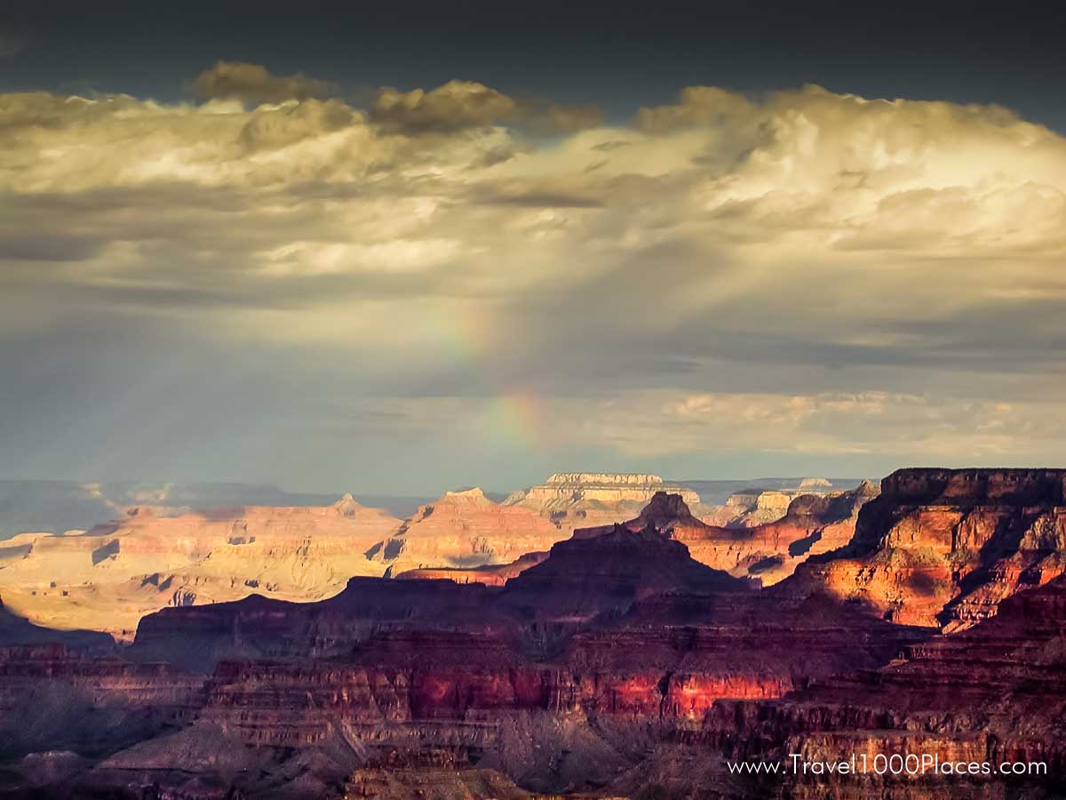
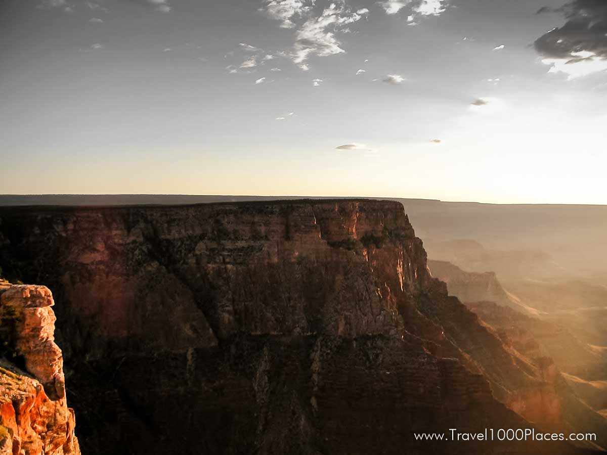
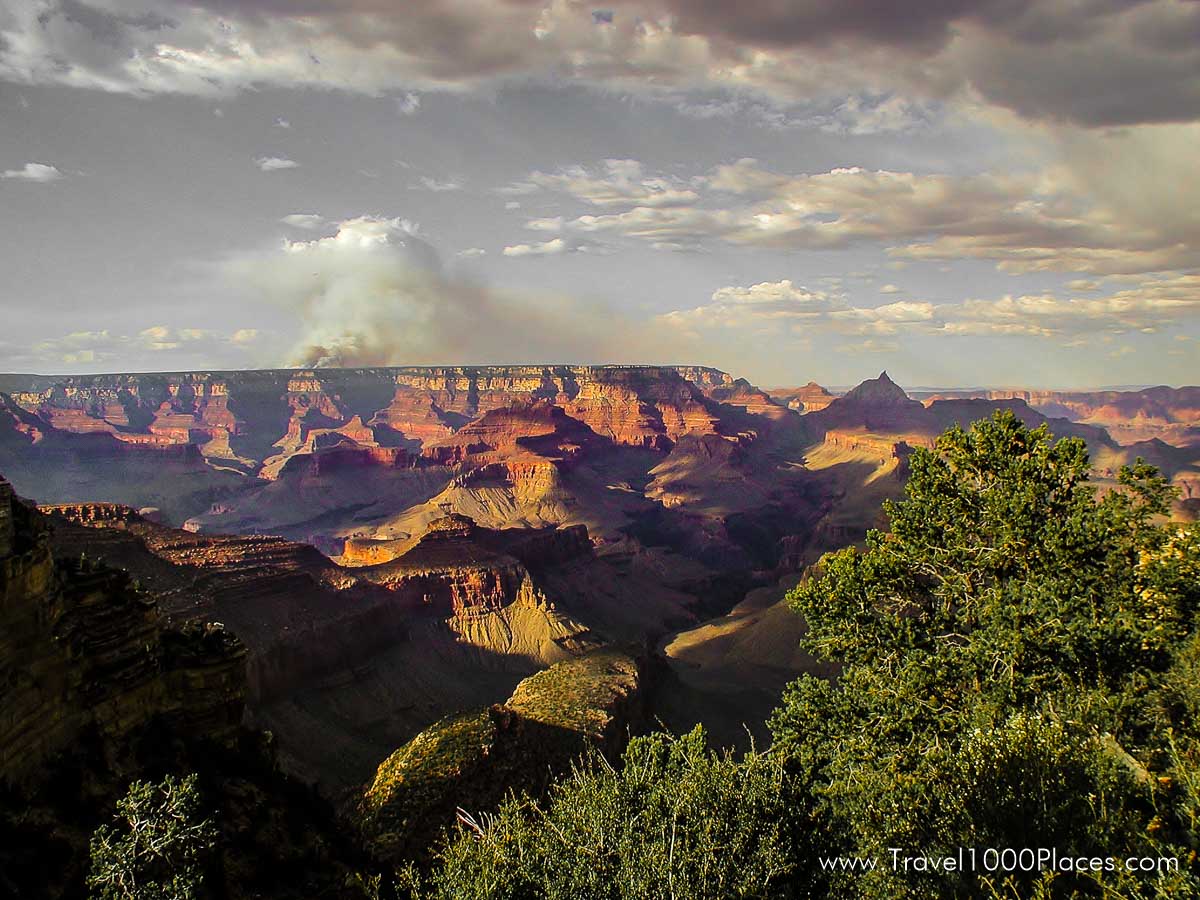
For viewing and photographing the canyon, the best light is early or late in the day (as you may be know…). Mid-day sun tends to flatten the view and soften the colors. Remember that days are short in the winter and long in the summer. If you plan to see the canyon at sunrise or sunset, it is recommended that you be on the rim at least 1 hour before. Usually the view points get crowded early before sunrise/sunset.
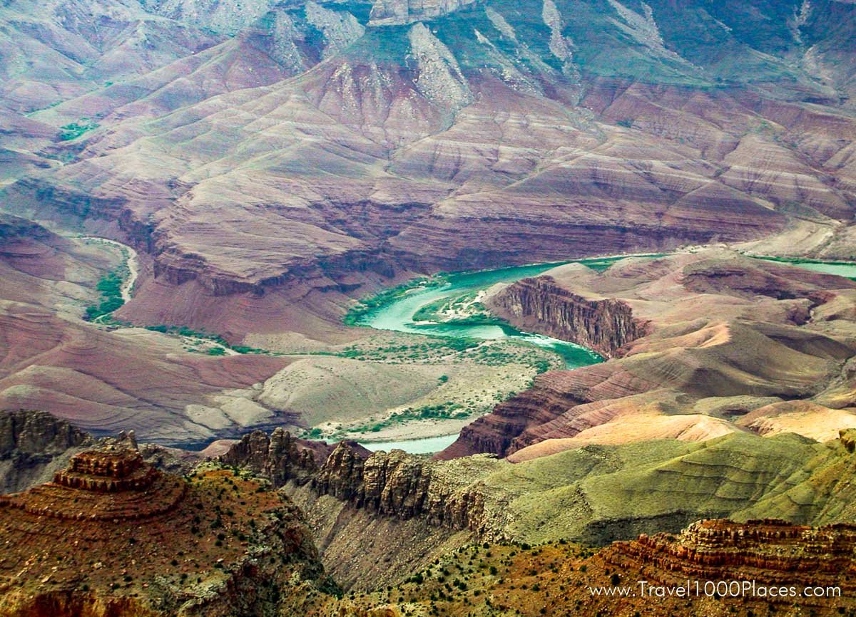
Colorado River
The Colorado River flows along the bottom of the canyon, 5000 feet/1524 m below the rim. Because of the enormous depth of Grand Canyon, the river is visible only from certain viewpoints. It is a two-day hike to the river and back from the South Rim. It’s a longer trip from the North Rim. It is possible to drive to the Colorado River at Lees Ferry (near Marble Canyon, Arizona), a 2.5 hour drive (one way) from the South Rim. Lees Ferry marks the official beginning of Grand Canyon.
Altitude
The South Rim of Grand Canyon averages 7000 feet/2134 m above sea level. Visitors with respiratory or heart problems may experience difficulties. All walking at this elevation can be strenuous.
Reservations for camping and lodging are essential. When making reservations for lodging and camping, remember to identify the rim you plan on visiting.
The North Rim
The North Rim is over 8000 feet/2438 m above sea level. Visitor services and facilities inside the national park on the North Rim are only open from mid May to mid October.
The North Rim is by far not so developed for tourism as the South Rim is. Only few of the nearly 5 million Grand Canyon visitors visit the North Rim, most of them hikers.
The North Rim is situtated 10 air miles north of the South Rim. If you consider the hike through the canyon it will take 2 to 3 days to finish the 21 miles. If you drive around the canyon it takes 4 to 5 hrs to reach the adjacent side after ca. 220 miles (354 km). Raods to the North Rim are usually closed between November and mid-may due to harsh winter conditions.
Altitude Visitors with respiratory or heart problems may experience difficulties. All walking at this elevation can be strenuous.
Reservations for camping and lodging are essential. When making reservations for lodging and camping, remember to identify the rim you plan on visiting.
